Faisalabad Hostels welfare Association
This is Faisalabad hostels association for girls and boys
Faisalabad ( /fɑːɪsɑːlˌbɑːd/; Punjabi, Urdu: فیصل آباد, Punjabi pronunciation: [fɛːsə̆ləˌbäːd]; Urdu pronunciation: [fɛːsˈlɑˌbɑːd] ⓘ), formerly known as Lyallpur (Punjabi, Urdu: لائل پور), is the 3rd largest city of Pakistan after Karachi and Lahore respectively. It is second largest city and industrial heart of Punjab, Pakistan. With an estimated population of 3.8 million in 2024, it is the second-largest Punjabi-speaking city in the world.
Historically one of the largest villages of Punjab, Lyallpur was one of the first planned cities within British India. It was restructured into city district status; a devolution promulgated by the 2001 local government ordinance (LGO). The total area of Faisalabad District is 5,856 km2 (2,261 sq mi)[7] while the area controlled by the Faisalabad Development Authority (FDA) is 1,326 km2 (512 sq mi).[8][9]: 8
Faisalabad has become a major industrial and distribution hub due to its centrally located infrastructure (connecting roads, rails, and air transportation).[10] It has been referred to as the Manchester of Pakistan because of its extensive textile industry.[11][12] As of 2013, the GDP of Faisalabad was estimated at $43 billion[13] and projected to rise to $87 billion in 2025 at a growth rate of 5.7%.[14] Faisalabad contributes over 10 percent to the Punjab's GDP and has an average annual GDP (nominal) of $20.5 billion.[13] Agriculture and industry remain its hallmarks.[15][9]: 41
Etymology
[edit]
Faisalabad was formerly (until 1977) known as Lyallpur. When founded in 1890 it was named after Sir James Broadwood Lyall, the British lieutenant governor of the Punjab.[16][17] It became headquarters of the Lower Chenab colony and in 1898 was incorporated as a municipality.[18]
In September 1977, the city of Lyallpur was renamed "Faisalabad" by the Government of Pakistan for Saudi Arabian king Faisal bin Abdulaziz Al Saud and his kingdom's long relationship with Pakistan and its people.[19]
History
[edit]
The first university in Lyallpur was built by the British Indian Empire in 1906 with the foundation stone laid by Sir Louis Dane, then Lieutenant and Governor of Punjab.[20]
Mohammed Ali Jinnah, in Lyallpur where he gave a historic speech at Dhobi Ghat, c. 1943
One of the earlier industrial exhibition at the University of Agriculture, still a major exhibition in the city today, c. 1949
Lady Mountbatten, Vicereine of India, among the Hindu evacuees at the Punjab Scouts Camp, Layallpur during partition of British India
Gurudawar Layallpur, a Sikh Gurdwara constructed during the reign of the British Empire in 1911
Toponymy
[edit]
The city was settled or established in 1880 during the colonisation of the lower Chenab Valley.[21] This city was settled down by Rai Bahadur Bhavanidas Sikka, after which the British Government granted jagirs to him. After Partition his descendants settled in India, now settled in Mumbai. This city was named in honour of Lieutenant-Governor of the Punjab, Sir James Broadwood Lyall, for his role in establishing the canal colonisation project.[22][23] The surname Lyall was joined with the noun pur, meaning 'city' in Sanskrit.[24]
On 1 September 1977, the Government of Pakistan changed the name of the city from Lyallpur to Faisalabad ('City of Faisal') in honour of King Faisal of Saudi Arabia, who made several financial contributions to Pakistan.[21][25][7]
Early settlements
[edit]
The region encompassing modern day Faisalabad district was originally inhabited by a number of forest-dwelling tribes.[22] It is believed these early settlements belonged to the ancient districts of Jhang and Sandalbar, and included the area between Shahdara to Shorekot and Sangla Hill to Toba Tek Singh.[21] The shrine of Baba Noor Shah Wali was erected in the area in the 1600s.[26]
Development
[edit]
At the conclusion of the Second Anglo-Sikh War in 1849, the entire Punjab region became administered as Punjab province, firstly by the East India Company and after 1858 as part of the British Raj.[27][28]
In the 1880s the Punjab government began an irrigation scheme to cultivate large tracts of western Punjab through the creation of canal colonies.[29] The Chenab colony was the largest of these colonisation projects, and covered the entirety of present-day Faisalabad district. Popham Young, the Colonisation Officer managing the project identified the site of the current city to establish headquarters for the colony.[22][30]
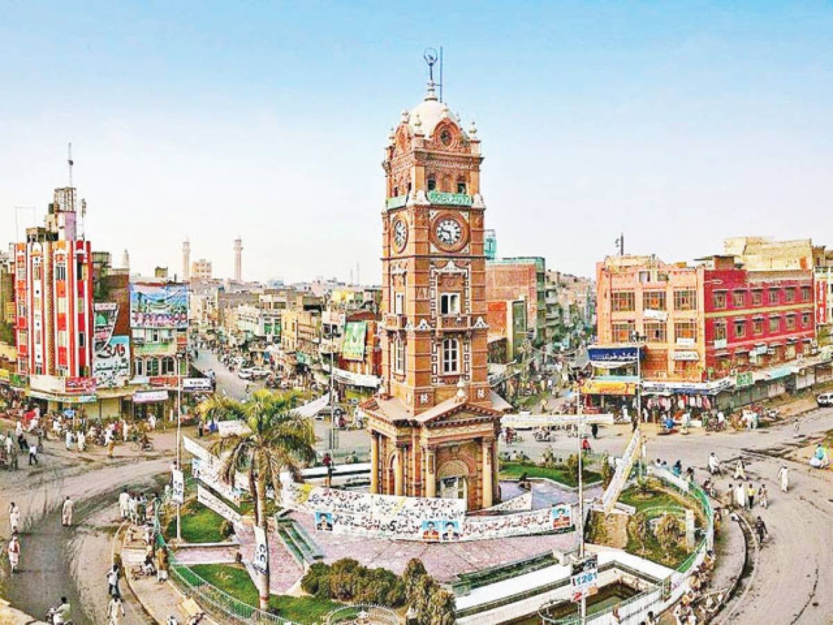
Young designed the settlement's centre to replicate the design in the Union Jack with eight roads extending from a large clock tower at its epicentre;[31] a design geometrically symbolic of the Cross of Saint Andrew counter changed with the Cross of Saint Patrick, and Saint George's Cross over all.[32] The eight roads developed into eight separate bazaars (markets) leading to different regions of the Punjab.[23][33] In 1892, the newly constructed town with its growing agricultural surplus was added to the British rail network.[34] Construction of the rail link between Wazirabad and Lyallpur was completed in 1895.[31] In 1896, Gujranwala, Jhang and Montgomery comprising the Tehsils of Lyallpur were under the administrative control of the Jhang District.[35] The town became one of the first planned settlements within British India.[15]
In 1904, the new district of Lyallpur was created to include the tehsils of Samundri and Toba Tek Singh with a sub-tehsil at Jaranwala, which later became a full tehsil in itself.[36] The University of Agriculture, originally the Punjab Agricultural College and Research Institute, Lyallpur, was established in 1906.[20] The Town Committee was upgraded to a Municipal Committee in 1909. Lyallpur grew into an established agricultural tool and grain centre.[37] By 1911 the city had a population of 19,578.[22] The 1930s brought industrial growth and market expansion to the textile industry as well as to food processing, grain crushing and chemicals.[23]
Independence
[edit]
In August 1947, following three decades of nationalist struggles, India and Pakistan achieved independence. The British agreed to partition British India into two sovereign states – Pakistan with a Muslim majority, and India with a Hindu majority. However, more Muslims remained in India than what governing authorities believed would assimilate into Pakistan.[38] The partitioning led to a mass migration of an estimated 10 million people which made it the largest mass migration in human history.[38] The Punjab province was divided into Punjab, West Pakistan and Punjab, India. There were also respective divisions of the British Indian Army, the Indian Civil Service, various administrative services, the central treasury, and the railways.[39] Riots and local fighting followed the expeditious withdrawal of the British, resulting in an estimated one million civilians deaths, particularly in the western region of Punjab.[38] Lyallpur, which was located in the region of the Punjab Province that became West Pakistan, was populated by a minority of Hindus and Sikhs who migrated to India, while Muslim refugees from East Punjab settled in the district.[39]
In 1977, Pakistani authorities changed the name of the city from Lyallpur to Faisalabad, in order to honor the close friendship of King Faisal of Saudi Arabia with Pakistan.[40]
During the eighties, the city saw an influx of foreign investments in the textile sector.[41] Large number of residents of Faisalabad began working abroad as bilateral ties improved as part of new trade agreements. This led to more foreign remittances into the city. This aided the development of large scale infrastructure projects within the city.[7] In 1985, the city was upgraded as a division with the districts of Faisalabad, Jhang and Toba Tek Singh.[21]


